Friday, June 26, 2009

Mount San Jacinto Via Marion Mountain Trail (Tuesday, June 23, 2009) Sort of

The day began with high hopes of bagging one the three highest peaks in Southern California. I woke up at around 3:40 in the morning excited to see the majestic views of Mount San Jacinto Peak, namely the Salton Sea. We left the mountain around 3:45 defeated without reaching the summit. All in all, it was one of the most challenging hikes thus far and I enjoyed pushing my limits getting up most of mountain.


View Mount San Jacinto in a larger map


Randy, Alex, and Anthony (Virgin Hike) came by my house around 4:00 A.M. and we were off on our San Jacinto adventure. It was a long ride from the house to Banning where we traveled south toward the Marion Mountain Trail. We ended up reaching the campground around 6:15 and made our preparations for the day's hike. I had a couple of new toys with me on the hike which I was excited to use, a new camera, and a Garmin GPS Navigation device. They had been gifts from my lovely wife for various occasions and I could not wait to get them going. If you notice the picture quality from the Mount Baldy post, I was using a six year old camera from Jennifer which did not come out too clear. The new camera would suit me just fine.


We entered the trail head for the Marion Mountain Trail at around 6:15 and began the 5 1/4 trek up the trail to the summit. I must say that in preparation for the hike, I had read up bit on this particularly trail and it was described as a "butt buster." That is definitely a valid assessment. The first mile of the Trek was steep and long. It seemed to take us forever to get the junction with the Pacific Coast Trail 2.8 miles up the path. As we were on our way, I was defiantly feeling the steep accent in my quads and shins. I had to stop several times during the first mile because my legs were shot, this slowed the group down considerably, and I was reminiscent of the Mount Baldy hike, where Al, Randy, and J.B. coined the phrase "Dave duty." I was determined to not have this moniker follow me this trip so I pushed on and as we cleared the first part of the trail, my legs began to become acclimated with the hike and usable again. I was really impressed with the way Anthony did for much of the hike. It being his first time and all, kept a steady pace for much of the hike.


After the first mile of the trail, we seemed to lose the trail and veered of west of the trail approaching the Seven Pines Trail. We tried, in vain, for an hour and a half, to pick up the Marion Trail further along the route to continue our journey up the San Jacinto Mountain but could not locate it. The long detour took a lot out of some of us and by the time we picked up the trail head and continued the Marion mountain trail, it was nearly 10:00. This detour was a devastating blow to our hopes of reaching the summit, but under Randy's determination we pressed on pushing our way towards the summit.


Mount San Gorgonio


Mount Baldy


The next part of the trail head up through some boulders and and intersects the famed Pacific Crest Trail. From there we followed the trail to the treeline towards the Little Round Valley which was about 1 1/2 miles from the San Jacinto Summit. We never got that far.

Following the Deer Springs trail we crossed a stream on the North Fork of the San Jacinto River where Randy was able to fill up is pack and filter some cold and refreshing water. This was much need as even though were were traveling higher in elevation, the weather was getting a bit hotter.


Getting water from the creek


Energy


Go Dirtbags


As we trekked up the mountain, through heavy thickets of brush that scraped the you know what out of our legs, discussions were starting to envelop the group as to the turn back time. It had been decided that if we did not get to Little Round Valley by 1:30, then we would head back. We ended up reaching a section of boulders nearing the treeline where we stopped for a break. It was around 1:15 and we were still a couple of miles from San Jacinto peak. In fact we could see both the peak and Little Round Valley up ahead. It was determined that we should begrudgingly cut our trek and head back down. This was a bitter sweet moment as we head trekked up to about 9500 feet and could see the goal, but we knew that reaching it was a good 2 - 2 1/2 hours away. So we tossed our stuff down and had lunch. Even though we did not reach the summit, it was nice to relax for a little bit and hang out while taking in the incredible views from that area.


Mount San Jacinto Peak
Soooo Close


Little Round Valley


The Gnome was to heartbroken to make an appearance.


The trek down to the car was done at a swift pace which we reached in a couple of hours. Disappointment about not reaching the summit quickly faded away as I was looking forward to reaching the car and eating at Del Taco. Even though we were able to reach the car at 3:45, the trek became a bit difficult as the weather increased as we dropped in altitude. I kept thinking of the 90 degree weather that was waiting for us in Banning when we got down the mountain. I had used the GPS device to travel up the mountain marking spots along the trail, and it had played a role in finding the trail after we had been lost, but it became most handy on the way down when I figured out how to navigate to the car. This feature allowed us to track the miles that remained on the hike and went along way for improving morale.


Anthony, ready to bail.


This was a beautiful hike with some pretty spectacular views of the San Gorgonio Valley. At points along the trail we were able to look back and spot Mount Baldy. I enjoyed hiking through pine forests, boulders, and creeks. Even though we did not make the summit, I still enjoyed getting out into nature and spending time with great friends.

Tuesday, May 19, 2009

Timber Mountain Via Icehouse Trail (Tuesday, April 14, 2009)


This hike was really enjoyable as the canyon lead into some pretty amazing views of the nearby peaks. Our second trek deep into the San Gabriel Mountains was along and cold but amazing.
The day began by waking up at 4:30 A.M. and scrambled to get ready and include all that I was bringing along. Mariel, Jennifer, Randy, and Alex picked me up around 5:00 as we headed toward the 210 East towards Mountain Road. The drive included coffee, Rockstar Drinks and some Macaroons for Passover, the perfect hiking food by the way. After about an hour and fifteen minute drive, we arrived at the Icehouse Canyon. We parked and got ready for the hike ahead. We entered the trail head at around 6:30 and began the hike into the picturesque Cucamunga Wilderness. 


The trail leading towards the wilderness was a steady incline as we slowly increased altitude. I really enjoyed following the creek where we could hear the flowing water follow us along the trail. It was an easy hike up to the Cucamunga Wilderness. Along the trail we passed some cabins who were situated right on the creek.


At one point along the trail, the group reached the skeleton remains of an abandoned house where Alex found a perfect hiking stick, which he titled the "poking stick." Inspired by his find, I was hell bent to find one of my own, being that I was too cheap to purchase hiking poles from REI. On Mount Baldy, I had the brilliant idea of bringing my ski poles, but much similar to the laptop that I had brought on our Baseball Road Trip around the Western states in '02, they stayed in the car wasting space. I ended up finding one further one the trail which I called Moses


The hike followed a path flanked by the creek and up some boulders to the entrance of the Cucamunga Wilderness. The cool weather along with the beautiful scenery made this portion of the hike go rather quickly.


Our second stop along way was Icehouse Saddle which was only about 0.9 miles from Timber Mountain. The saddle was windy and cold but opened up some amazing views of Cucamunga Peak to the East, Big Horn Peak to the South, Timber Mountain and Telegraph Peaks to the North, and Mount Baldy to the South. We took a slight water and beef jerky break here and gazed at wondrous creation of nature before our eyes.


From the Saddle, we connected with the Three T's Trail for final accent up Timber mountain. This part of the journey saw the incline of the trail become a bit steeper and we encountered some switchbacks. Some in the group began to feel the coming affects of the altitude.


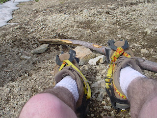
The highlight of the hike, or at least in my opinion, was strapping on the crampons to our feet as the final quarter mile of the hike to the summit had some snow on it. Randy and I had been monitoring the weather conditions of the Icehouse peak area along with the San Gorgonio and San Jacinto wildernesses to decide which peak to try. It was decided that Timber Mountain saw the best chance of the group to summit a mountain so we chose Timber Summit. Randy rented crampons from REI just in case we needed them. We though we did and put them on only to see a guy passing us without them. I really enjoyed hiking up the face of the mountain and am definitely hooked on winter hiking for next year, thanks Todd for your inspiration.


Need sun desperately


The summit rewarded us with some pretty amazing views of the peaks of the nearby peaks. After toasting our accomplishment of this hike with some drinks, we sat down on a log conveniently located there to eat and take in the scenery. This offered me a chance to continue my self imposed tradition of eating my lunchable at the top and to take pictures of the surrounding scenery and place our hiking mementos on the summit sign. This did not come without incident as, while still in my spikes. I borrowed Mariel and Jennifer's camera to take better shots, but tripped over the log just barely saving the camera.


Mariel, Checking the map


Majestic Mount Baldy


Cucamunga Peak


Mount Baldy


Rest in Peace Nick Adenheart


The Gnome and the Dinty Moore Can of Beef Stew


Old Glory from the summit.


After about 45 minutes of hanging out at the summit, we decided slide down the other side of the mountain to what looked like another summit or at least a hill on the other side of Timber Mountain. Twenty minutes later, Alex, Randy, and I came to the edge of this hill and partook in the breathtaking views of the Mojave Desert to the east and Mount San Gorgonio to the south east but not before Alex took me out thinking it was a race. This will be paid back another time. As we got back to Timber Mountain, we discussed going on to Telegraph Peak, only about two miles further towards
Mount Baldy, so that we could knock another peak off the list of highest in Southern California. We decided against this because dark clouds began to form around Cucamunga Peak and Mount Baldy. This was a sign for us to head back to the car. A good decision by the group because the temperature dropped considerable on the way back as the wind began to pick up.


Mojave Desert to the East


The Captain Mount San Gorgonio taunting us.


We took the same trail back to the car. Much similar to Baldy, it was long and tedious after we got back to the Icehouse Saddle. From there many in the group just wanted to get back to the car. As we passed the skeletal remains of house, Alex left his hiking stick nobly for the next hiker to use.


All in all, this was an incredible hike with spectacular views. I enjoyed the Icehouse Canyon and the peaks that surrounded. We began this new hobby in our lives last year and look forward to exploring more of the wilderness of Southern California as we prepare ourselves to hike Mount Whitney next year. A lofty but achievable goal. Nice to share these accomplishments with great friends.

Late,

Dave

Summit counter:

Randy (5): Mount Baldy, Mount Pinos, Mount San Gorgonio, Half Dome, and now Timber Mountain
Alex (4): Mount Baldy, Mount Pinos, Half Dome, and now Timber Mountain
Dave (2): Mount Baldy, and now Timber Mountain
Jennifer (2): Mount Pinos and now Timber Mountain
Mariel (2): Mount Pinos and now Timber Mountain